|
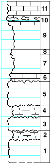
| Unit No. |
Description |
Thickness |
|
|
Fort Riley limestone member
|
|
|
11
|
Limestone, massive, porous and cavernous, with Aviculopecten, small Derbyia, Leda, and Bellerophon
|
3 ft.
|
|
10
|
Limestone, massive, soft with some chert at the top and scattered fossils: Meekella striaticostata, small Derbyia, small crinoid joints
|
2 ft.
|
|
|
Oketo shale member
|
|
|
9
|
Shale, bluish-gray, very fossiliferous, Derbyia and other fossils
|
5 ft.
|
|
8
|
Mudstone, bluish-gray, bedded with numerous echinoid spines
|
1 ft.
|
|
7
|
hale, bluish-gray, with two calcareous fossiliferous beds near the top: chiefly crinoid joints
|
4 ft.
|
|
6
|
Limestone, massive, numerous echinoid spines, also crinoid joints, Rhipidomella, Dictyoclostus americanus, stony bryozoa, Fenestella and others
|
1.6 ft.
|
|
|
Florence limestone member
|
|
|
5
|
Limestone, with bands of flint
|
4.8 ft.
|
|
4
|
Shale, calcareous, with weathered pyrite concretions
|
2.2 ft.
|
|
3
|
Limestone with bands of flint
|
3 ft.
|
|
2
|
Shale, limy, with Fenestella, stony bryozoa, Chonetes, Derbyia, Dictyoclostus americanus and others
|
1.7 ft.
|
|
1
|
Limestone with bands of flint
|
5 ft.
|
|
