|
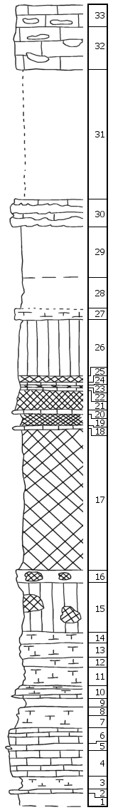
| Unit No. |
Description |
Thickness |
|
|
Cresswell Limestone Member
|
|
|
33
|
Limestone, with band of flint nodules near the base
|
2 ft.
|
|
32
|
Limestone with few scattered flint nodules. Numerous echinoid remains, also Derbya
|
4 ft.
|
|
|
Grant Shale Member
|
|
|
31
|
Covered
|
12.5 ft.
|
|
|
Stovall Limestone Member
|
|
|
30
|
Limestone largely replaced by flint, with Dictyoclostus, Pinna, bryozoa, Myalina, few Derbya, Composita, echinoid and crinoid remains
|
2.4 ft.
|
|
-
|
(Note: 1 1/2 mi. SW of Woodbine, below the Stovall limestone is exposed mudstone, 1' thick, with Myalina, Allorisma, and crinoid joints, and below this bed 1' thick calcareous shale with numerous Derbya and crinoid joints
|
|
|
|
Gage Shale Formation
|
|
|
29
|
Covered
|
4.5 ft.
|
|
28
|
Shale, gray
|
3 ft.
|
|
27
|
Limestone, greenish-gray, splittery
|
1 ft.
|
|
26
|
Shale, green, with net of calcareous veinlets
|
5.5 ft.
|
|
25
|
Shale, purple
|
0.5 ft.
|
|
24
|
Shale, green
|
0.2 ft.
|
|
23
|
Shale, maroon
|
0.3 ft.
|
|
22
|
Shale, mottled, purple and green
|
0.2 ft.
|
|
21
|
Shale, maroon
|
2.2 ft.
|
|
20
|
Shale, green
|
0.1 ft.
|
|
19
|
Shale, maroon
|
1 ft.
|
|
18
|
Mudstone, green
|
0.2 ft.
|
|
17
|
Shale, maroon to red, occasionally green spots and breccias
|
13.5 ft.
|
|
16
|
Limestone, knotty, brecciated, crystalline, gray, yellow and pink, cavernous
|
1.5 ft.
|
|
15
|
Shale, mottled, green and pink
|
4.5 ft.
|
|
14
|
Shale, chalky, light-gray
|
1 ft.
|
|
13
|
Shale, gray, calcareous to "box work"
|
1 ft.
|
|
12
|
Limestone, yellow-gray, with small Murchisonia and microfauna (?)
|
1 ft.
|
|
11
|
Shale, chalky, yellow-gray
|
2 ft.
|
|
|
Towanda Limestone Formation
|
|
|
10
|
Limestone, rusty gray, splittery porous, with Murchisonia and microfauna (?)
|
1.2 ft.
|
|
9
|
Shale, gray
|
0.9 ft.
|
|
8
|
Mudstone, rusty-gray, porous, with Murchisonia and microfauna (?)
|
1 ft.
|
|
7
|
Shale, calcareous, rusty-gray, porous
|
1 ft.
|
|
6
|
Limestone, light gray, flaggy, cavernous near the top
|
1.5 ft.
|
|
5
|
Shale, calcareous
|
0.5 ft.
|
|
4
|
Limestone, light gray, splittery
|
2.5 ft.
|
|
3
|
Shale, gray, rusty
|
1.4 ft.
|
|
2
|
Limestone, gray, banded
|
0.1 ft.
|
|
|
Holmesville Shale Members
|
|
|
1
|
Shale, rusty gray
|
1 ft.
|
|