KGS Home

Geology Index Page

Dickinson County

Sec. 29, T. 15 S., R. 4 E
Move to another county

Measured By M.K. Elias, 1932
Remarks: V-4
Unit No. Description Thickness
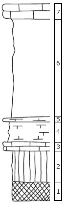
  Herington Limestone Member  
7 Limestone 2 ft.
  Paddock Shale Member  
6 Shale 13.5 ft.
  Krider Limestone Member  
5 Limestone, splittery 0.5 ft.
4 Shale, somewhat calcareous, the following fossils in the upper 2' and in the limestone above: Derbya, Composita, crinoid joints, bryozoa 3 ft.
3 Limestone, tough, yellow-hued gray, with pelecypods and Murchisonia 1 ft.
  Odell Shale Formation  
2 Shale, green 4.5 ft.
1 Shale, red 2.5 ft.

Original Document

The Archive file you download contains a TIFF image compressed into a ZIP archive. Your browser may be already set up to decompress these files. Commercial software to perform this is available from PKWARE, Inc., the company that invented the format. A web page from a group of people creating shareware or public domain software is available at Info-ZIP. The TIFFs are 150-dpi archival-quality color scans of the original forms and can be viewed by software like Corel PhotoPaint or Adobe PhotoShop. To read the PDF version, you will need the Acrobat PDF Reader, available free from Adobe.


Kansas Geological Survey
Comments to webadmin@kgs.ku.edu
URL=http://www.kgs.ku.edu/General/Geology/Measured/index.html
Programs Updated May 2003