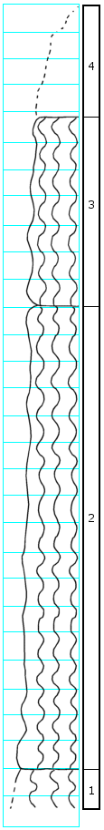
KGS Home

Geology Index Page

Dickinson County

Sec. 25, T. 16 S., R. 1 E
Move to another county

On west side of draw
Measured By N. Plummer, Dec. 2, 1951
Unit No. Description Thickness
4 Soil cover 3-5 ft.
3 Clay, gray and dark red, mottled, red tends to occur in vertical streaks, blocky, fairly plastic 7.0 ft.
2 Clay, mostly fairly light gray with some darker, with irregular stain and patches, upper 2 feet seems to be clean of stain, and other levels also seem to be all gray 17.0 ft.
1 Clay, exposed below bed 3, but due to dip or cross-bedding, exact thickness of clay is difficult to determine  

Original Document

The Archive file you download contains a TIFF image compressed into a ZIP archive. Your browser may be already set up to decompress these files. Commercial software to perform this is available from PKWARE, Inc., the company that invented the format. A web page from a group of people creating shareware or public domain software is available at Info-ZIP. The TIFFs are 150-dpi archival-quality color scans of the original forms and can be viewed by software like Corel PhotoPaint or Adobe PhotoShop. To read the PDF version, you will need the Acrobat PDF Reader, available free from Adobe.


Kansas Geological Survey
Comments to webadmin@kgs.ku.edu
URL=http://www.kgs.ku.edu/General/Geology/Measured/index.html
Programs Updated May 2003