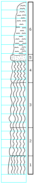
KGS Home

Geology Index Page

Dickinson County

Sec. 30, T. 16 S., R. 2 E
Move to another county

Exposure on N side of small knoll, about 0.12 miles S of road
Measured By N.V. Plummer and W.B. Hladik, Oct. 13, 1951
Unit No. Description Thickness
6 Silt, light gray and yellow, to sand 6.0 ft.
5 Sandstone, yellow and light gray, slightly resistant 0.7 ft.
4 Clay, slightly silty, light putty gray with pinkish tinge in upper 0.7' 2.5 ft.
3 Clay, rather dark gray, plastic, with irregular yellow stain 5.3 ft.
2 Clay, slightly silty, light gray with some yellow; a few red spots at bottom 3.2 ft.
1 Clay, red; beds tend to be lenticular; exposed below bank  

Original Document

The Archive file you download contains a TIFF image compressed into a ZIP archive. Your browser may be already set up to decompress these files. Commercial software to perform this is available from PKWARE, Inc., the company that invented the format. A web page from a group of people creating shareware or public domain software is available at Info-ZIP. The TIFFs are 150-dpi archival-quality color scans of the original forms and can be viewed by software like Corel PhotoPaint or Adobe PhotoShop. To read the PDF version, you will need the Acrobat PDF Reader, available free from Adobe.


Kansas Geological Survey
Comments to webadmin@kgs.ku.edu
URL=http://www.kgs.ku.edu/General/Geology/Measured/index.html
Programs Updated May 2003