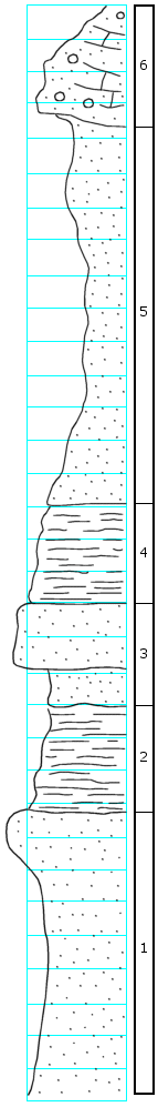
KGS Home

Geology Index Page

Morton County

Sec. 12, T. 34 S., R. 43 W
Move to another county

About 1/8 mile E of point of rocks on north side of Cimarron River
Measured By D.F. Merriam, June 23, 1957
Unit No. Description Thickness
6 Mortar beds, Ogallala 3 + ft.
5 Sandstone, yellow-brown, poorly exposed 11.5 ft.
4 Shale, some as 2 3.0 ft.
3 Sandstone, yellow-brown, stained reddish, hard at top 3.0 ft.
2 Shale, dark red, silty, platy 3.2 ft.
1 Sandstone, yellow-brown, even horizontal bed, medium green 8 ft.

Original Document

The Archive file you download contains a TIFF image compressed into a ZIP archive. Your browser may be already set up to decompress these files. Commercial software to perform this is available from PKWARE, Inc., the company that invented the format. A web page from a group of people creating shareware or public domain software is available at Info-ZIP. The TIFFs are 150-dpi archival-quality color scans of the original forms and can be viewed by software like Corel PhotoPaint or Adobe PhotoShop.


Kansas Geological Survey
Comments to webadmin@kgs.ku.edu
URL=http://www.kgs.ku.edu/General/Geology/Measured/index.html
Programs Updated May 2003