|
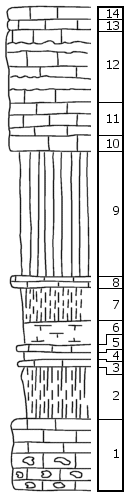
| Unit No. |
Description |
Thickness |
|
|
Shroyer Limestone (top eroded; thickness remaining, about 12')
|
|
|
14
|
Limestone, weathered
|
1 + ft.
|
|
13
|
Limestone, weathered shaly
|
1 ft.
|
|
12
|
Limestone, with several bands of chert
|
6 ft.
|
|
11
|
Limestone, disintegrated and shale-like
|
2.5 ft.
|
|
10
|
Limestone, massive, non-cherty, weathers yellowish
|
1.25-1.5 ft.
|
|
|
Havensville Shale
|
|
|
9
|
Shale, olive, argillaceous
|
10-11 ft.
|
|
8
|
Flagstone, quite firm, dark gray
|
1 + ft.
|
|
7
|
Shale, dark gray, loosely indurated, weathers yellow, shelly
|
3 ft.
|
|
6
|
Shale, not firm, weathers yellowish
|
2 ft.
|
|
5
|
Flagstone, dark gray
|
0.42-0.5 ft.
|
|
4
|
Shale
|
0.42 ft.
|
|
|
Limestone and Shale, Havensville (?), Fourmile Limestone (?)
|
|
|
3
|
Limestone, earthy, very fossiliferous, with pelecypods, etc.
|
0.5 ft.
|
|
2
|
Shale, dark gray, argillaceous, bedded, forms dark flakes
|
4.5 ft.
|
|
1
|
Fourlime limestone, top weathered; the rest quite cherty
|
6 + ft.
|
|