|
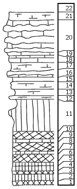
| Unit No. |
Description |
Thickness |
|
22
|
Shale
|
|
|
21
|
Shale, calcareous, splittery
|
1 ft.
|
|
|
Threemile Limestone Member
|
|
|
20
|
Limestone, massive, with three flint bands
|
5 ft.
|
|
19
|
Shale, calcareous
|
0.2 ft.
|
|
18
|
Limestone
|
0.7 ft.
|
|
17
|
Shale, calcareous
|
0.9 ft.
|
|
16
|
Limestone, with flint band
|
1 ft.
|
|
|
Speiser Shale Formation
|
|
|
15
|
Shale, with Chonetes
|
0.5 ft.
|
|
14
|
Shale, calcareous, with Aviculopecten, Pseudomonotis, Chonetes, Juresania, Orbiculoidea, Straparollus, crinoid joints
|
0.8 ft.
|
|
13
|
Shale
|
1 ft.
|
|
12
|
Mudstone with Pinna, Myalina, Aviculopecten, Pseudomonotis, Astartella, Juresania, Septopora
|
0.5 ft.
|
|
11
|
Shale, green, calcareous in middle part
|
4.5 ft.
|
|
10
|
Shale, maroon
|
1.1 ft.
|
|
9
|
Shale, green
|
0.3 ft.
|
|
8
|
Shale, brick red
|
1.1 ft.
|
|
7
|
Shale, green
|
0.2 ft.
|
|
6
|
Shale, maroon
|
0.8 ft.
|
|
5
|
Shale, green
|
0.3 ft.
|
|
4
|
Shale, dark bluish-green
|
0.5 ft.
|
|
3
|
Shale, purple
|
0.4 ft.
|
|
2
|
Shale, dark bluish-green
|
0.7 ft.
|
|
1
|
Shale, mottled, green and purple
|
0.5 + ft.
|
|