|
| Unit No. |
Description |
Thickness |
|
|
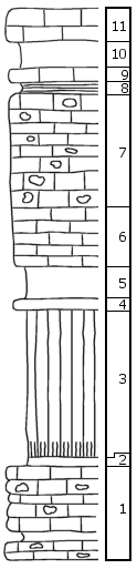
Schroyer Limestone
|
|
|
11
|
Limestone, gray, non-cherty, massive, weathers dark gray, irregular and pitted
|
2.5-3 ft.
|
|
10
|
Shale, olive green, argillaceous, weathers yellowish
|
2 ft.
|
|
9
|
Limestone
|
1 ft.
|
|
8
|
Shale, black, fissile, argillaceous
|
1 + ft.
|
|
7
|
Limestone, cherty
|
8.5 +/- ft.
|
|
6
|
Limestone, gray, non-cherty, somewhat shaly, weathers yellowish, about
|
4-5 ft.
|
|
|
Havensville Shale
|
|
|
5
|
Shale, gray, quite fossiliferous
|
2.5 ft.
|
|
4
|
Limestone, gray, somewhat shaly
|
0.5 ft.
|
|
3
|
Shale, not well exposed, olive colored, except about 1' at base, which is nearly black
|
11 ft.
|
|
2
|
Shale, dark gray, very limy, fossiliferous, transition to member below
|
0.5-1 ft.
|
|
1
|
Fourmile limestone, light gray, cherty, with 6" to 1' of gray, fossiliferous shale about 1' 6" above base
|
7-7.5 ft.
|
|