|
| Unit No. |
Description |
Thickness |
|
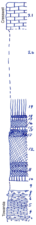
21
|
Cresswell Limestone
|
10 ft.
|
|
20
|
Covered
|
26.5 ft.
|
|
19
|
Shale, green
|
6.2 ft.
|
|
18
|
Shale, red
|
1 ft.
|
|
17
|
Shale, green
|
0.7 ft.
|
|
16
|
Shale, red
|
3 ft.
|
|
15
|
Shale, green
|
6 ft.
|
|
14
|
Shale, red
|
1 ft.
|
|
13
|
Shale, calcareous, splittery, mottled red and greenish-gray
|
1.5 ft.
|
|
12
|
Shale, red
|
10 ft.
|
|
11
|
Shale, red, with green bands
|
5 ft.
|
|
10
|
Shale, green
|
1.5 ft.
|
|
9
|
Covered
|
4 ft.
|
|
8
|
Limestone, bedded, crumbly, shaly, with small pelecypods and gastropods
|
1.5 ft.
|
|
7
|
Limestone, chalky (--5, 6, 7: with colorless impressions of sea-weeds)
|
0.5 ft.
|
|
6
|
Shale, calcareous, platy, greenish
|
1.5 ft.
|
|
5
|
Limestone, platy
|
0.5 ft.
|
|
4
|
Limestone, flaggy, greenish, on top few small high spired gastropods; in lower 2 ft. high spired gastropods and foraminifera (?)
|
3 ft.
|
|
3
|
Limestone, platy
|
0.8 ft.
|
|
2
|
Limestone, massive, with Murchisonia (?) and Pleurophorus
|
0.4 ft.
|
|
1
|
Limestone, platy
|
0.8 ft.
|
|