|
| Unit No. |
Description |
Thickness |
|
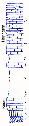
11
|
Limestone, light gray, flaggy
|
14.5 ft.
|
|
10
|
Limestone, light gray, weathers yellowish and oolitic. Pseudomontis and other pelecypods in basal 0.3'
|
10 ft.
|
|
9
|
Covered
|
4.5 ft.
|
|
8
|
Limestone, yellowish-gray, coquinoid, porous, pelecypods and gastropods in lower half
|
2 ft.
|
|
7
|
Shale, mostly covered
|
12 ft.
|
|
6
|
Shale, light yellowish to gray, Orbiculoidea
|
0.5 ft.
|
|
5
|
Shale, yellowish-gray
|
2.5 ft.
|
|
4
|
Limestone, light yellowish-gray, Aviculopecten and Pseudomonotis in upper part
|
5 ft.
|
|
3
|
Limestone, shaly, light gray
|
1 ft.
|
|
2
|
Shale, green
|
3 ft.
|
|
1
|
Shale, red
|
3 ft.
|
|