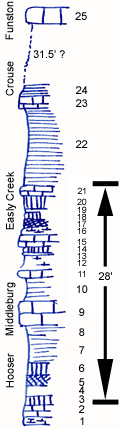
| Unit No. |
Description |
Thickness |
|
26
|
Limestone, oolitic, massive, limestone brown (Funston)
|
2 ft.
|
|
25
|
Covered
|
31.5 ft.
|
|
24
|
Shale, hard calcareous yellowish gray with dark gray spots
|
+ 1.5 ft.
|
|
23
|
Limestone brown coquinoid
|
1.5 ft.
|
|
22
|
Shale black
|
10 ft.
|
|
21
|
Limestone light gray
|
1.5 ft.
|
|
20
|
Shale greenish gray
|
1.5 ft.
|
|
19
|
Shale yellow
|
0.5 ft.
|
|
18
|
Shale green
|
1 ft.
|
|
17
|
Shale dark purple to maroon above
|
1 ft.
|
|
16
|
Shaly lime dark brown green algae
|
1 ft.
|
|
15
|
Limestone gray with green algae
|
1.5 ft.
|
|
14
|
Shale yellowish green
|
0.5 ft.
|
|
13
|
Limy shale
|
0.5 ft.
|
|
12
|
Shale yellowish green lime streaks
|
2 ft.
|
|
11
|
Limestone light gray banded
|
1 ft.
|
|
10
|
Shale black lower part with upper 1 ft. yellowish gray
|
3 ft.
|
|
9
|
Limestown light brown massive, bryozoa, Derbya crassa, Dictyoclosta
|
3 ft.
|
|
8
|
Shale dark blue to black
|
1.5 ft.
|
|
7
|
Shale greenish gray
|
3.5 ft.
|
|
6
|
Shale mottled green limy
|
1.5 ft.
|
|
5
|
Shale dark purple
|
1.5 ft.
|
|
4
|
Shale yellow & dark gray mottle limy
|
1.5 ft.
|
|
3
|
Shale dark green
|
1 ft.
|
|
2
|
Limestone light brown Coquina
|
1 ft.
|
|
1
|
Shaly lime
|
|