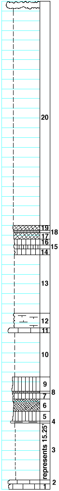
|
| Unit No. |
Description |
Thickness |
|
|
Top of Florence flint (approximately)
|
|
|
20
|
Covered, flint at the top
|
46 ft.
|
|
|
Blue Springs shale formation
|
|
|
19
|
Shale, purple
|
1 ft.
|
|
18
|
Shale, dark-green
|
0.5 ft.
|
|
17
|
Shale, purple
|
1.5 ft.
|
|
16
|
Shale, light-green
|
1 ft.
|
|
15
|
Shale, dark-green
|
0.8 ft.
|
|
14
|
Shale, light-green
|
1.2 ft.
|
|
13
|
Covered
|
12 ft.
|
|
|
Kinney limestone formation
|
|
|
12
|
Shale, calcareous, with soft pink pebbles, Derbyia, Allorisma and bryozoa
|
3 ft.
|
|
11
|
Limestone, tough, light-gray, with pebbles of pink shale and fragments of shells
|
1 ft.
|
|
|
Wymore shale formation
|
|
|
10
|
Covered, probably mostly green shale
|
9 ft.
|
|
9
|
Shale, green
|
3 ft.
|
|
8
|
Shale, red
|
0.2 ft.
|
|
7
|
Shale, green
|
1.3 ft.
|
|
6
|
Shale, red
|
2.5 ft.
|
|
5
|
Shale, green
|
2 ft.
|
|
4
|
Mudstone, light-gray
|
0.25 ft.
|
|
3
|
Covered
|
15.25 ft.
|
|
2
|
Limestone, with numerous fragments of shells
|
1 ft.
|
|
1
|
Mudstone, massive
|
1 ft.
|
|

