|
| Unit No. |
Description |
Thickness |
|
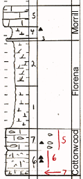
5
|
Limestone
|
2.25 ft.
|
|
4
|
Shale, calcareous, with red chert
|
1.25 ft.
|
|
3
|
Limestone
|
0.25 ft.
|
|
2
|
Shale, clolomitic; weathers blocky toward bottom; yellowish gray; no fossils
|
5.2 ft.
|
|
1
|
Shale, calcareous, fossiliferous; obscure bedding; yellow with conspicuous lenses of dark gray
|
5.0 ft.
|
|
7
|
Limestone, abundant fusulines; nodules chert in lower third; weathers buff
|
2.5 ft.
|
|
6
|
Limestone, bioclastic; echinoderm fragments, corals, bryozoa, brachiopods, chert nodules toward upper part; buff weathering
|
3 ft.
|
|