|
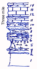
| Unit No. |
Description |
Thickness |
|
14
|
Limestone, shaly at the base
|
1.5 ft.
|
|
13
|
Limestone, massive, harder on top
|
1.5 ft.
|
|
12
|
Limestone, massive, base flaggy
|
1.7 ft.
|
|
11
|
Limestone, with float band at top
|
2 ft.
|
|
10
|
Limestone, with two flint bands in upper part. Enteletes below the upper, thicker band
|
1.8 ft.
|
|
9
|
Flint
|
1 ft.
|
|
8
|
Shale, calcareous, with crinoids joints and Composita
|
1.5 ft.
|
|
7
|
Limestone with three flint bands, Wellerella in first and second (from the bottom) and in between
|
2.2 ft.
|
|
6
|
Limestone
|
0.3 ft.
|
|
5
|
Shale, calcareous, with quartz veins, Chonetes granulifer, Derbya crassa, Composita, Orbiculoidea, Wellerella, Juresania, Ambocoelia, bryozoa, Schizostania, crinoid joints. In basal 1 ft. shells are encrusted by algal growth
|
3.5 ft.
|
|
4
|
Limestone, clayey, with Pinna
|
0.5 ft.
|
|
3
|
Shale, gray, clayey
|
1 ft.
|
|
2
|
Vein of quarry
|
0.1 ft.
|
|
1
|
Covered, mostly shale
|
+ 5 ft.
|
|