|
| Unit No. |
Description |
Thickness |
|
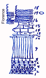
18
|
Flint
|
|
|
17
|
Limestone with 3 flint bands. Fusulinids in the middle band. Small Rhipodomella in the upper band
|
2 ft.
|
|
16
|
Limestone with 3 flint bands
|
2 ft.
|
|
15
|
Limestone, shaly, splittery
|
2 ft.
|
|
14
|
Limestone, massive, with Pinna, Dentalinn?, Bellerophon, Schizodus, Myalina, Allorisma, Derbya crassa, Dictyoclostus (near top), Enteletes
|
1 ft.
|
|
13
|
Shale, calcareous
|
1 ft.
|
|
12
|
Limestone, shaly
|
0.5 ft.
|
|
11
|
Shale
|
0.2 ft.
|
|
10
|
Limestone
|
0.3 ft.
|
|
9
|
Shale, green, yellowish on top
|
6.5 ft.
|
|
8
|
Shale, light green
|
1 ft.
|
|
7
|
Shale, purple
|
0.5 ft.
|
|
6
|
Shale, light green
|
0.5 ft.
|
|
5
|
Shale, light purple
|
0.5 ft.
|
|
4
|
Shale, light green, with canal-like extensions in the underlying shale
|
0.5 ft.
|
|
3
|
Shale, maroon
|
1.5 ft.
|
|
2
|
Shale, purple
|
0.4 ft.
|
|
1
|
Shale, green
|
+ 0.1 ft.
|
|