|
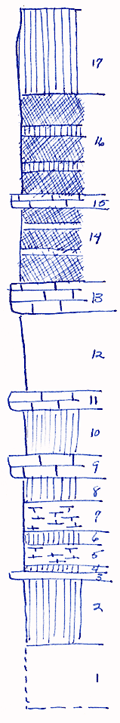
| Unit No. |
Description |
Thickness |
|
17
|
Shale, olive, massive
|
7.5 ft.
|
|
16
|
Shale, red, with bands of greenish-gray
|
9 ft.
|
|
15
|
Mudstone, gray, probably correlative with the Bruno Limestone
|
1 ft.
|
|
14
|
Shale, largely red, some gray in bands
|
7 ft.
|
|
|
Kinney Limestone
|
|
|
13
|
Limestone, shaly or limy shale, greenish-gray, composed of Compositas, Productids, Myalinas, bryozoa, etc.
|
2.5 ft.
|
|
12
|
Shale, gray, limy, fossiliferous
|
+ 7 ft.
|
|
11
|
Limestone, gray
|
1.5 ft.
|
|
10
|
Mudstone and shale, olive to gray
|
4 ft.
|
|
9
|
Limestone, gray, massive, with pelecypods at top
|
2 ft.
|
|
|
Wymore Shale
|
|
|
8
|
Shale, olive to greenish-gray, loosely indurated
|
2.5 ft.
|
|
7
|
Mudstone, shaly, weathers platy
|
2.5 ft.
|
|
6
|
Shale, olive, limy
|
1 ft.
|
|
5
|
Mudstone, shaly, weathers bedded
|
2 ft.
|
|
4
|
Shale, olive
|
0.5 ft.
|
|
3
|
Limestone, gray, arenaceous
|
0.5 ft.
|
|
2
|
Shale, greenish-gray, with some calcareous aggregate
|
6 ft.
|
|
1
|
Covered slope
|
5.66 ft.
|
|