|
| Unit No. |
Description |
Thickness |
|
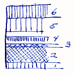
6
|
Shale, dark olive, weathers crumbly
|
2 ft.
|
|
5
|
Shale, olive drab, massive, calcareous
|
2 ft.
|
|
4
|
Shale, greenish-gray, massive, with sub-zone of darker color near middle
|
1.5 ft.
|
|
3
|
Shale, lavendar, massive to bedded
|
0.5 ft.
|
|
2
|
Shale, chocolate-maroon, massive
|
2 ft.
|
|
1
|
Shale, olive, massive
|
0.66 - 1 ft.
|
|