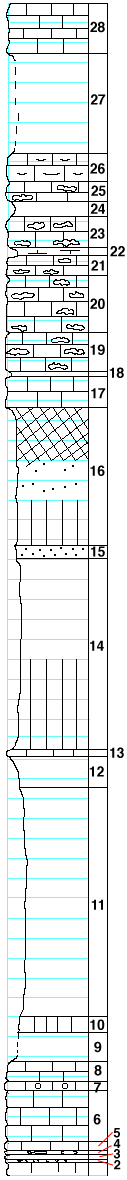
|
| Unit No. |
Description |
Thickness |
|
28
|
Limestone
|
5+ ft.
|
|
27
|
Covered
|
10 ft.
|
|
26
|
Limestone, shaly
|
3 ft.
|
|
25
|
Limestone with fossils and a little chert
|
2 ft.
|
|
24
|
Shales, yellow, with fossils
|
1.4 ft.
|
|
23
|
Limestone with 3 to 4 layers of concretionary chert
|
3.33 ft.
|
|
22
|
Shale, calcareous, or marl
|
0.75 ft.
|
|
21
|
Limestone with thick chert layer below and 4 inch layer in upper part
|
2 ft.
|
|
20
|
Limestone with 7 layers of concretionary chert
|
5.5 ft.
|
|
19
|
Limestone with 4 layers of concretionary chert
|
4 ft.
|
|
18
|
Shales, fossiliferous, equals layers below flint at Marysville
|
0.5 ft.
|
|
17
|
Limestone, argillaceous
|
3 ft.
|
|
16
|
Shales, red and green with sandstone layer
|
14 ft.
|
|
15
|
Sandstone, soft red
|
1.25 ft.
|
|
14
|
Shales, clayey, blue, olive, and green
|
19 ft.
|
|
13
|
Limestone, blue
|
1 ft.
|
|
12
|
Shales, blue clayey
|
3 ft.
|
|
11
|
Talus, by barometer
|
25 ft.
|
|
10
|
Shales, green, showing in creek bank
|
1.5 ft.
|
|
9
|
Covered, creek bed
|
3 ft.
|
|
8
|
Limestone, gray, clayey
|
2 ft.
|
|
7
|
Limestone, very compact with smooth fracture, solid geodes
|
1 ft.
|
|
6
|
Limestone, very dark blue, argillaceous
|
5 ft.
|
|
5
|
Limestone, 6 inches to 1 foot, with fragments of fossils beneath bridge
|
1 ft.
|
|
4
|
Chert
|
0.41-0.5 ft.
|
|
3
|
Limestone, blue with fragments of fossils
|
0.5 ft.
|
|
2
|
Chert
|
0.33 ft.
|
|
1
|
Limestone, thin layers below high water at the mouth of the creek. Farther out in the river a layer of chert may be seen at low water
|
|
|
