|
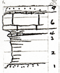
| Unit No. |
Description |
Thickness |
|
9
|
Sandstone, brownish, hard, fine, dense, weathers light tan
|
0.8 ft.
|
|
8
|
Shale, covered
|
+/- 0.3 ft.
|
|
7
|
Limestone, light gray & dark brown, mottled, pseudo-brecciates, algal
|
0.2 ft.
|
|
6
|
Limestone, gray, weathers light yellowish brown, massive to irregular, slabby, had Amblusiphonella, crinoid stems, fenestrate, bryozoa, Dictyoclostus
|
3 ft.
|
|
5
|
Shale, clay, light gray in lower part, yellowish above, unfossiliferous
|
0.6 ft.
|
|
4
|
Limestone, light gray, weathers light gray to white, contains small Fus., Ottohosia, weathers to shaly streak & locally absent
|
0.2 ft.
|
|
3
|
Shale, yellow, very calcareous, highly fossiliferous, Rhombopora, large Derbya, Chonetes, granulifer, Marginifera, Lasallinies, Neospirifer, and crinoid stems
|
0.9 ft.
|
|
2
|
Shale, clay, dark drab blue below grading up to brownish soft plastic laminates
|
+/- 4 ft.
|
|
1
|
Sandstone, light tan, fine micacious +/- X bedded, grades into shaly sandstone
|
1 ft.
|
|