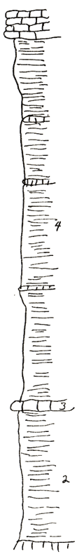
KGS Home

Geology Index Page

Coffey County

Sec. 36, T. 20 S., R. 13 E
Move to another county

Southeast of Hartford - measured in the road
Unit No. Description Thickness
5 Limestone - white, fusulinids, cephalopods, gastropods +/- 2 ft.
4 Shale - with thin beds of limestone thin, black, septaria 28 ft.
3 Limestone - septaria 0.5 ft.
2 Shale - blue gray, covered 10.2 ft.
1 Limestone - black, earthy, platy - gray to buff shale to Creek bottom 0.5 ft.

Original Document

The Archive file you download contains a TIFF image compressed into a ZIP archive. Your browser may be already set up to decompress these files. Commercial software to perform this is available from PKWARE, Inc., the company that invented the format. A web page from a group of people creating shareware or public domain software is available at Info-ZIP. The TIFFs are 150-dpi archival-quality color scans of the original forms and can be viewed by software like Corel PhotoPaint or Adobe PhotoShop.


Kansas Geological Survey
Comments to webadmin@kgs.ku.edu
URL=http://www.kgs.ku.edu/General/Geology/Measured/index.html
Programs Updated May 2003