|
| Unit No. |
Description |
Thickness |
|
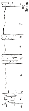
1
|
Big Springs and Beil, poorly shown
|
|
|
2
|
Greenish clay shale below, calcareous in upper part, filled above with very fine Myalina subquadrata, Astartella, and Nuculana arata
|
13 ft.
|
|
3
|
Calcareous brown sandstone, filled with mollusks, very limy at top
|
2 ft.
|
|
4
|
Gray clay shale
|
7 ft.
|
|
5
|
Riffled sandstone
|
4 ft.
|
|
6
|
Covered shale
|
12 ft.
|
|
7
|
Osagia Limestone
|
1.5 ft.
|
|
8
|
Shaly nodular limestone with Derbya, Chonetes transversalis, and Myalina
|
5 ft.
|
|
9
|
Limestone in creek bed
|
|
|