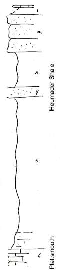
Measured By Newell, 04/1936
|

|
|
|
| Unit No. |
Description |
Thickness |
|
1
|
Flaggy blue wilty limestone and shale shown in section to north just above scarp forming sandstone (Kereford)
|
|
|
2
|
Massive blocky brown sandstone
|
+/- 10 ft.
|
|
3
|
Sandy shale
|
10 ft.
|
|
4
|
Soft calcareous buff sandstone
|
3 ft.
|
|
5
|
Greenish and gray clay shale with limonite concretions, lower 5 feet or so marly with sponges, mollusks, and other fossils coated with algae
|
42 ft.
|
|
6
|
Plattsmouth limestone
|
|
|
Original Document
The Archive file you download contains a TIFF image compressed into a ZIP archive.
Your browser may be already set up to decompress these files.
Commercial software to perform this is available from
PKWARE, Inc., the company that invented the format.
A web page from a group of people creating shareware or public
domain software is available at Info-ZIP.
The TIFFs are 150-dpi archival-quality color scans of the original forms and can be viewed by software like Corel PhotoPaint or Adobe PhotoShop.
|