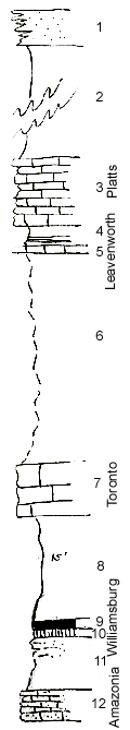
KGS Home

Geology Index Page

Coffey County

Sec. 10, T. 20 S., R. 17 E
Move to another county

Road Exposure
Measured By Newell, 04/1936
Composite made from sections 10, 11, and 15
 
Unit No. Description Thickness
1 Massive buff sandstone, remnant + 5 ft.
2 Clay shale, gray 50 ft.
3 Wavy, light gray limestone with cryptozoon 9 ft.
4 Shale, lower half black, fissile, with phoyh. concretions 3 ft.
5 Dense blue limestone with fusulinids, blochy 0.9 ft.
6 Covered shale 28 ft.
7 Buff heavy limestone with fusulinids 7 ft.
8 Gray and buff, sandy shale 15 ft.
9 Coal (Williamsburg) 1 ft.
10 Underclay 1 ft.
11 Covered sandy beds +/- 7 ft.
12 Interbedded silty limestone and shale with crinoid stems locally weathers like sandstone + 4 ft.
  Beds 1 and 2 are probably in the Heumader member  

Original Document

The Archive file you download contains a TIFF image compressed into a ZIP archive. Your browser may be already set up to decompress these files. Commercial software to perform this is available from PKWARE, Inc., the company that invented the format. A web page from a group of people creating shareware or public domain software is available at Info-ZIP. The TIFFs are 150-dpi archival-quality color scans of the original forms and can be viewed by software like Corel PhotoPaint or Adobe PhotoShop.


Kansas Geological Survey
Comments to webadmin@kgs.ku.edu
URL=http://www.kgs.ku.edu/General/Geology/Measured/index.html
Programs Updated May 2003