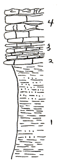
KGS Home

Geology Index Page

Coffey County

Sec. 10, T. 21 S., R. 15 E
Move to another county

Roadctus on highway and section line road to the east, 2 miles North of Burlington
Measured By Baptist, Noff, and Wallace
Covered interval to top of Plattsmouth at least 6 ft.
Unit No. Description Thickness
4 Shale, brown and blue, silty, fossiliferous with Myalina, euphemites, Euomphalus, Phorkidonotus, good collecting, exposed 18 ft.
3 Limestone, blue gray weathers buff, single ledge, fine grained, dense, smoth fracture 0.5 ft.
2 Limestone, earthy, weathers brown, slabby with buff shale partings 2.1 ft.
1 Limestone, blue gray, weathers brown, hard resistant irregular pitted weathering, gastropods, crinoid stems, fucoids 4.5 ft.

Original Document

The Archive file you download contains a TIFF image compressed into a ZIP archive. Your browser may be already set up to decompress these files. Commercial software to perform this is available from PKWARE, Inc., the company that invented the format. A web page from a group of people creating shareware or public domain software is available at Info-ZIP. The TIFFs are 150-dpi archival-quality color scans of the original forms and can be viewed by software like Corel PhotoPaint or Adobe PhotoShop.


Kansas Geological Survey
Comments to webadmin@kgs.ku.edu
URL=http://www.kgs.ku.edu/General/Geology/Measured/index.html
Programs Updated May 2003