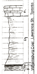
KGS Home

Geology Index Page

Coffey County

Sec. 10, T. 21 S., R. 17 E
Move to another county

Gully crop 75 yards Southeast of Jennings house
Measured By A.L. Bowsher, 07/24/1942
On Jenning's Farm
Unit No. Description Thickness
6 Thin-bedded, brown, hard, slabby, dense, very fine grained, crystalline. fusuliniferous limestone with ferr. fossil cavities  
5 Light gray, fairly hard, thin-bedded, kaolinitic, illite clay shale 18 - 19 ft.
4 Thin-bedded, platy, bituminous coal - Williamsburg 6 - 9 in.
3 Very soft, somewhat shaly coal 0 - 3 in.
2 Interbedded, gray, soft, kaolinitic clay shale and lignite layers 0 - 3 in.
1 Dark gray, soft, very thin-bedded, slightly kaolinitic illite clay shale, containing a great amount of browken lignitic material 1 ft.

Original Document

The Archive file you download contains a TIFF image compressed into a ZIP archive. Your browser may be already set up to decompress these files. Commercial software to perform this is available from PKWARE, Inc., the company that invented the format. A web page from a group of people creating shareware or public domain software is available at Info-ZIP. The TIFFs are 150-dpi archival-quality color scans of the original forms and can be viewed by software like Corel PhotoPaint or Adobe PhotoShop.


Kansas Geological Survey
Comments to webadmin@kgs.ku.edu
URL=http://www.kgs.ku.edu/General/Geology/Measured/index.html
Programs Updated May 2003