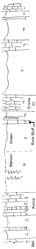
| Unit No. |
Description |
Thickness |
|
1
|
Remnant of silty buff limestone with brachiopods and cryptozoan
|
+ 3 ft.
|
|
2
|
Limy shale
|
2.5 ft.
|
|
3
|
Sandstone
|
0.5 ft.
|
|
4
|
Silty and sandy buff shale
|
8 ft.
|
|
5
|
Coquinoid and sandy limestone with crinoids and mollusks
|
4 ft.
|
|
6
|
Covered olive sandy shale, upper part very sandy
|
17 ft.
|
|
7
|
Wavy buff limestone with cryptozoans
|
6 ft.
|
|
8
|
Shale lower part black with phosphatic concrs
|
3 ft.
|
|
9
|
Blaocky, dense, blue, fusulinids
|
1.5 ft.
|
|
10
|
Green clay shale
|
10 ft.
|
|
11
|
Covered shale maroon at top
|
55 ft.
|
|
12
|
Wavy buff limestone with T cf ventricosus, Compophyllum, ans Syringopora
|
3 ft.
|
|
13
|
Gray shale
|
2 ft.
|
|
14
|
Earthy gray limestone with T cullomensis
|
1 ft.
|
|
15
|
Limy gray shale
|
1 ft.
|
|
16
|
Even blocky limestone with T cullomensis
|
1 ft.
|
|
17
|
Greenish shale with small variety of Myalina subquadrata at top
|
4.5 ft.
|
|
18
|
Yellow unfossiliferous limestone (marlite)
|
1 ft.
|
|
19
|
Limy nodular shale
|
3.5 ft.
|
|
20
|
Osagia Limestone (top of Beil)
|
|