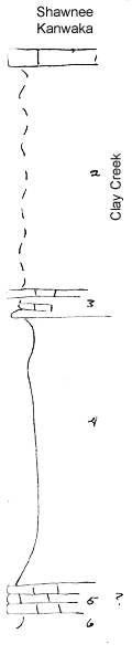
Measured By Newell, 04/1936
|
|
|
|
| Unit No. |
Description |
Thickness |
|
1
|
Irregular brown Osagia limestone
|
2 ft.
|
|
2
|
Covered interval
|
25 ft.
|
|
3
|
Platy limestone & limy shale with Myalina, subquad, Schizodus, Derbya, Chonetes transversalis
|
+/- 3 ft.
|
|
4
|
Clay shale with concretions
|
30 ft.
|
|
5
|
Brown limestone Osagia & Myalina in upper part
|
3 ft.
|
|
6
|
Sandy shale
|
|
|
Original Document
The Archive file you download contains a TIFF image compressed into a ZIP archive.
Your browser may be already set up to decompress these files.
Commercial software to perform this is available from
PKWARE, Inc., the company that invented the format.
A web page from a group of people creating shareware or public
domain software is available at Info-ZIP.
The TIFFs are 150-dpi archival-quality color scans of the original forms and can be viewed by software like Corel PhotoPaint or Adobe PhotoShop.
|