|
| Unit No. |
Description |
Thickness |
|
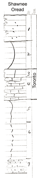
1
|
Shaly buff sandstone
|
10 ft.
|
|
2
|
Sandy greenish Limestone
|
10 ft.
|
|
3
|
Coquinoid, light gray massive
|
3 ft.
|
|
4
|
Brownish to gray limestone with a few fusulinids, corals, (un-readable word found in record, could be a type of coral), rather massive
|
8 ft.
|
|
5
|
Olive silty shale
|
8 ft.
|
|
6
|
Covered shale
|
14 ft.
|
|
7
|
Shaly & sandy limestone with mollusks, brachiopods, and bryozoa
|
+ 5 ft.
|
|