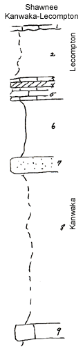
Measured By Newell, 04/1936
|
|
|
|
| Unit No. |
Description |
Thickness |
|
1
|
Gray limestone with T. cullomensis (Avoca)
|
+ 2 ft.
|
|
2
|
Covered shale
|
10 ft.
|
|
3
|
Yellow unfossiliferous limestone
|
0.5 ft.
|
|
4
|
Cross-bedded limestone full of fusulinids
|
|
|
5
|
Fine buff & gray limestone with fusulinids
|
2 ft.
|
|
6
|
Gray shale
|
12 ft.
|
|
7
|
Sandstone
|
2 - 3 ft.
|
|
8
|
Mostly covered variegated shale & sandstone
|
32 ft.
|
|
9
|
Nodular Osagia molluscan limestone
|
3 ft.
|
|
Original Document
The Archive file you download contains a TIFF image compressed into a ZIP archive.
Your browser may be already set up to decompress these files.
Commercial software to perform this is available from
PKWARE, Inc., the company that invented the format.
A web page from a group of people creating shareware or public
domain software is available at Info-ZIP.
The TIFFs are 150-dpi archival-quality color scans of the original forms and can be viewed by software like Corel PhotoPaint or Adobe PhotoShop.
|