|
| Unit No. |
Description |
Thickness |
|
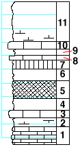
11
|
Shale, gray, argillaceous; dark and bedded at middle; calcareous and very fossiliferous in basal 1 foot which carries many specimens of Thamniscus octonarius, and some specimens of Septopora, Derbyia, etc.
|
6 ft.
|
|
10
|
Limestone, gray, fossiliferous, with high-spired gastropods, Thamniscus, Polypora, Fenestella, Septopora, etc.<
|
1 ft.
|
|
9
|
Shale, gray
|
1 ft.
|
|
8
|
Limestone, gray, blocky, grannular, with gastropods and some ostracods
|
0.42 ft.
|
|
7
|
Shale, olive colored, with nodular lime at top
|
1.5 ft.
|
|
6
|
Shale, not so plastic as division 5, weathers buff
|
1.83 ft.
|
|
5
|
Shale, red, with some gray
|
3 ft.
|
|
4
|
hale, gray, with platy seams
|
1.5 ft.
|
|
3
|
Limestone, gray, with crinoid joints in upper portion
|
1.5 ft.
|
|
2
|
Shale, gray, with some calcareous material
|
1.5 ft.
|
|
1
|
Mudstone, dark gray, bedded, loosely indurated
|
2.5 ft.
|
|
