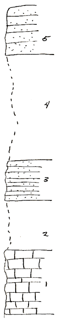
KGS Home

Geology Index Page

Coffey County

Sec. 2, T. 23 S., R. 15 E
Move to another county

South of Burlington junction of US 75 & Kansas 57
Measured By R.C. Moore, 11/08/1935
 
Unit No. Description Thickness
5 Sandstone caps bench 10 ft.
4 Shale with some thin sandstone 22 ft.
3 Sandstone light tan, weathers brownish, cross bedded in part grades to thin bedded sandstone 8 ft.
2 Shale yellowish gray & brownish sandy 10 ft.
1 Limestone weathers brown, massive, mid part thinner bedded & +/- slabby, numerous crinoid stems, brachiopods, (fusulinids not seen), top 6 ft. is mottled with light blue gray dense algal masses, +/- pseudobrecciated & has Osagia weathers more rounded & irregular. L. Oread 13 ft.

Original Document

The Archive file you download contains a TIFF image compressed into a ZIP archive. Your browser may be already set up to decompress these files. Commercial software to perform this is available from PKWARE, Inc., the company that invented the format. A web page from a group of people creating shareware or public domain software is available at Info-ZIP. The TIFFs are 150-dpi archival-quality color scans of the original forms and can be viewed by software like Corel PhotoPaint or Adobe PhotoShop.


Kansas Geological Survey
Comments to webadmin@kgs.ku.edu
URL=http://www.kgs.ku.edu/General/Geology/Measured/index.html
Programs Updated May 2003