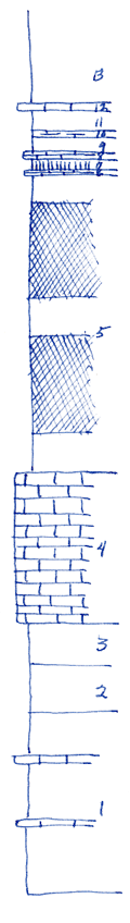
KGS Home

Geology Index Page

Marion County

Sec. 30, T. 21 S., R. 4 E
Move to another county

The Doyle formation exposed on Doyle Creek about seven miles southwest of Florence, Kansas
Measured By Condra & Upp, 1931
 
Unit No. Description Thickness
  Gage shale  
13 Shale, gray, with Derbyas and other fossils near top 8.5 ft.
12 Limestone, gray 0.66 ft.
11 Shale, gray 2 ft.
10 Shale, slabby 0.42 ft.
9 Shale, gray 1.5 ft.
8 Mudstone, weathers yellowish 0.5 ft.
7 Shale olive 1 ft.
6 Mudstone, light gray, limy 0.5 - 0.6 ft.
5 Shale, in bands of gray, red & gray, but largely red 26 ft.
4 Towands, limestone, weathers buff, part sandstone 13 ft.
  Holmesville shale, about 24 ft.  
3 Shale, gray 3.5 - 4 ft.
2 Shale, medium light gray, very limy, granular 4 ft.
1 Shale, gray and thin bands of limestone and mudstone 16 ft.

Original Document

The Archive file you download contains a TIFF image compressed into a ZIP archive. Your browser may be already set up to decompress these files. Commercial software to perform this is available from PKWARE, Inc., the company that invented the format. A web page from a group of people creating shareware or public domain software is available at Info-ZIP. The TIFFs are 150-dpi archival-quality color scans of the original forms and can be viewed by software like Corel PhotoPaint or Adobe PhotoShop.


Kansas Geological Survey
Comments to webadmin@kgs.ku.edu
URL=http://www.kgs.ku.edu/General/Geology/Measured/index.html
Programs Updated May 2003