|
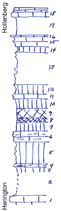
| Unit No. |
Description |
Thickness |
|
18
|
Limestone, flaggy in upper part (Hollenberg)
|
2 ft.
|
|
17
|
Shale, calcareous at the top
|
4 ft.
|
|
16
|
Limestone, hard
|
0.3 ft.
|
|
15
|
Limestone, chalky, harder in the middle
|
2.2 ft.
|
|
14
|
Shale, greenish gray
|
1.3 ft.
|
|
13
|
Shale, in places calcareous
|
7 ft.
|
|
12
|
Shale, green
|
2.2 ft.
|
|
11
|
Limestone, white, chalky, splittery
|
1 ft.
|
|
10
|
Shale, green
|
2 ft.
|
|
9
|
Shale, mottled purple and blue-green
|
2 ft.
|
|
8
|
Shale, maroon
|
1 ft.
|
|
7
|
Shale, green
|
2 ft.
|
|
6
|
Limestone, vesicular, greenish
|
2 ft.
|
|
5
|
Shale, green, somewhat indurated
|
5 ft.
|
|
4
|
Limestone, vesicular, irregular
|
0.7 ft.
|
|
3
|
Shale, green
|
0.8 ft.
|
|
2
|
Covered
|
5.5 ft.
|
|
1
|
Limestone (Herington)
|
|
|