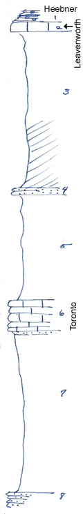
KGS Home

Geology Index Page

Wilson County

Sec. 26, T. 27 S., R. 13 E
Move to another county

Road exposure
Measured By Newell, 1938
Unit No. Description Thickness
1 Shale, block, fissile, phosphatic concretions + 2 ft.
2 Limestone, dense, blue, blocky 1.4 ft.
3 Shale, upper part slate-gray, lower part maroon (not well shown) 25 ft.
4 Siltstone, yellowish +/- 1 ft.
5 Shale, greenish buff above, maroon below 17 ft.
6 Limestone, gray and buff, wavy, filled with fusulinids, nodular and slaty at base 5 ft.
7 Shale mainly covered 25 ft.
8 Sandstone, platy, fine  

Original Document

The Archive file you download contains a TIFF image compressed into a ZIP archive. Your browser may be already set up to decompress these files. Commercial software to perform this is available from PKWARE, Inc., the company that invented the format. A web page from a group of people creating shareware or public domain software is available at Info-ZIP. The TIFFs are 150-dpi archival-quality color scans of the original forms and can be viewed by software like Corel PhotoPaint or Adobe PhotoShop.


Kansas Geological Survey
Comments to webadmin@kgs.ku.edu
URL=http://www.kgs.ku.edu/General/Geology/Measured/index.html
Programs Updated May 2003