|
| Unit No. |
Description |
Thickness |
|
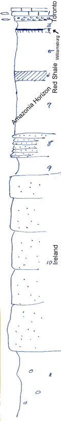
1
|
Limestone, gray, fine-grained, with abundant fusulinids
|
+ 2 ft.
|
|
2
|
Shale and limestone nodules, with innumerable fusulinids
|
1 ft.
|
|
3
|
Shale, gray and buff, clayey
|
2 ft.
|
|
4
|
Coal and underclay
|
0.3 ft.
|
|
5
|
Shale, greenish, clayey
|
9 ft.
|
|
6
|
Shale, maroon, clayey
|
+/- 2 ft.
|
|
7
|
Shale, poorly shown, mainly gray
|
12 ft.
|
|
8
|
Sandstone, platy, buff
|
5 ft.
|
|
9
|
Shale, silty, gray
|
4 ft.
|
|
10
|
Sandstone, massive
|
40 ft.
|
|
11
|
Shale, bluish-gray, clayey, with limonite concretions
|
+ 15 ft.
|
|

