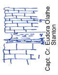
KGS Home

Geology Index Page

Wilson County

Sec. 36, T. 27 S., R. 16 E
Move to another county

Railroad cut
Measured By Newell
C.N. side 3-27-17 there is 3 ft. or so of block fissile shale below a limestone in Stanton. Structural relations bring Stanton so low topographically that the thickness or characters of the limestone under block shale cannot be determined Exposure of Capt Cr and Vilas immediately Northwest of here are normal but upper part of Capt Cr is commonly eroded. I believe this block shale to be a local facies of Eudora.
Unit No. Description Thickness
5 Bluish-gray, veined, thin-bedded and wavy, rather unfossiliferous + 6 ft.
4 Gray, limy shale, very fossiliferous, brachipod etc. 1.7 ft.
3 Gray and buff granular limestone 0.3 ft.
2 Gray limy shale, unfossiliferous 0.5 ft.
1 Heavy bedded, dense, gray limestone, brachiopods  

Original Document

The Archive file you download contains a TIFF image compressed into a ZIP archive. Your browser may be already set up to decompress these files. Commercial software to perform this is available from PKWARE, Inc., the company that invented the format. A web page from a group of people creating shareware or public domain software is available at Info-ZIP. The TIFFs are 150-dpi archival-quality color scans of the original forms and can be viewed by software like Corel PhotoPaint or Adobe PhotoShop.


Kansas Geological Survey
Comments to webadmin@kgs.ku.edu
URL=http://www.kgs.ku.edu/General/Geology/Measured/index.html
Programs Updated May 2003