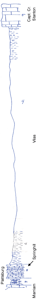
KGS Home

Geology Index Page

Wilson County

Sec. 8, T. 27 S., R. 17 E
Move to another county

Road exposures
Measured By Newell
Unit No. Description Thickness
5 Bluish gray, fine limestone, upper part white, crystalline + 10 ft.
4 Greenish-gray arg shale with limonite concretions in upper part; large cavo-convex algal "beads" just under Capt. Cr. 105 ft.
3 Irregular buff limestone, thin-bedded, and limy shale; filled with Heliospongia and Heterocallia 6 ft.
2 Limy gray shale, fossiliferous with limestone plates 3 ft.
1 Buff, blocky limestone +/- 1 ft.

Original Document

The Archive file you download contains a TIFF image compressed into a ZIP archive. Your browser may be already set up to decompress these files. Commercial software to perform this is available from PKWARE, Inc., the company that invented the format. A web page from a group of people creating shareware or public domain software is available at Info-ZIP. The TIFFs are 150-dpi archival-quality color scans of the original forms and can be viewed by software like Corel PhotoPaint or Adobe PhotoShop.


Kansas Geological Survey
Comments to webadmin@kgs.ku.edu
URL=http://www.kgs.ku.edu/General/Geology/Measured/index.html
Programs Updated May 2003