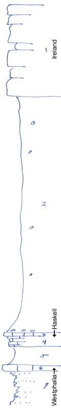
KGS Home

Geology Index Page

Wilson County

Sec. 23, T. 27 S., R. 13 E
Move to another county

Measured By Newell, 8/1938
Unit No. Description Thickness
1 Sandstone, massive + 40 ft.
2 Shale, bluish-gray, with limonite concretions, and phosphatic concretions at base 102 ft.
3 Limestone, bluish, blocky 1 ft.
4 Limestone, thin-bedded, irregular, buff & gray +/- 5 ft.
5 Shale, greenish, clayey, upper 1 ft. calcareous and buff 8 ft.
6 Limestone, brown, rather irregular, Osagia and a few fusulinids 2.5 ft.
7 Sandy shale and shaly sandstone + 20 ft.

Original Document

The Archive file you download contains a TIFF image compressed into a ZIP archive. Your browser may be already set up to decompress these files. Commercial software to perform this is available from PKWARE, Inc., the company that invented the format. A web page from a group of people creating shareware or public domain software is available at Info-ZIP. The TIFFs are 150-dpi archival-quality color scans of the original forms and can be viewed by software like Corel PhotoPaint or Adobe PhotoShop.


Kansas Geological Survey
Comments to webadmin@kgs.ku.edu
URL=http://www.kgs.ku.edu/General/Geology/Measured/index.html
Programs Updated May 2003