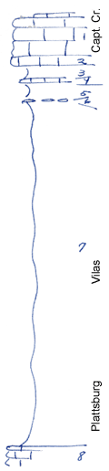
KGS Home

Geology Index Page

Wilson County

Sec. 14, T. 28 S., R. 16 E
Move to another county

Roadcuts
Measured By Newell, 8/1938
Unit No. Description Thickness
1 Limestone, white, with Enteletes and fusulinids, lower 1 ft. dove-gray + 9 ft.
2 Same as 1 + 2 ft.
3 Shale, buff, limy 3 ft.
4 Limestone, dense, blue, algal, with Punctospirifer and Ambocoelia on top 0.3 ft.
5 Silty shale with a few Hypselentoma perbumerosa 4 ft.
6 Small limestone concretions 0.2 ft.
7 Silty gray shale, unfossiliferous 82 ft.
8 Limestone with sponges, poorly shown  

Original Document

The Archive file you download contains a TIFF image compressed into a ZIP archive. Your browser may be already set up to decompress these files. Commercial software to perform this is available from PKWARE, Inc., the company that invented the format. A web page from a group of people creating shareware or public domain software is available at Info-ZIP. The TIFFs are 150-dpi archival-quality color scans of the original forms and can be viewed by software like Corel PhotoPaint or Adobe PhotoShop.


Kansas Geological Survey
Comments to webadmin@kgs.ku.edu
URL=http://www.kgs.ku.edu/General/Geology/Measured/index.html
Programs Updated May 2003