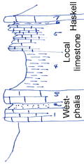
KGS Home

Geology Index Page

Wilson County

Sec. 13, T. 29 S., R. 13 E
Move to another county

Roadcuts
Measured By Newell
Unit No. Description Thickness
7 Bluish-gray, dense limestone with Cryptozoan 1.1 ft.
6 Buff, nodular shale 0.5 ft.
5 Gray and buff limestone 4.5 ft.
4 Gray and buff limy shale, replete with Myalina 6.5 ft.
3 Gray and buff, fine-grained irregular limestone 2.5 ft.
2 Brown limestone nodules 1 ft.
1 Brown ferruginous limestone, filled with Triticites and Osagia 2 ft.

Original Document

The Archive file you download contains a TIFF image compressed into a ZIP archive. Your browser may be already set up to decompress these files. Commercial software to perform this is available from PKWARE, Inc., the company that invented the format. A web page from a group of people creating shareware or public domain software is available at Info-ZIP. The TIFFs are 150-dpi archival-quality color scans of the original forms and can be viewed by software like Corel PhotoPaint or Adobe PhotoShop.


Kansas Geological Survey
Comments to webadmin@kgs.ku.edu
URL=http://www.kgs.ku.edu/General/Geology/Measured/index.html
Programs Updated May 2003