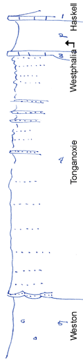
KGS Home

Geology Index Page

Wilson County

Sec. 13, T. 29 S., R. 13 E
Move to another county

Road exposures, creek banks
Measured By Newell, 8/1938
Unit No. Description Thickness
1 Limestone, light gray, dense, mottled, not very blocky here 1.5 ft.
2 Shale, limy, gray 11 ft.
3 Limestone, brown, nodular, algal, not very fossiliferous 1 ft.
4 Shaly sandstone, and sandy shale, "storm rollers" in lower part +/- 80 ft.
5 Gray-bluish clay shale with limonite concretions (cannot invariably be distinguished from lower part of preceding fm; however in good exposures the Weston does not have any sandstone whatsoever, and generally has limonite concretions + 20 ft.

Original Document

The Archive file you download contains a TIFF image compressed into a ZIP archive. Your browser may be already set up to decompress these files. Commercial software to perform this is available from PKWARE, Inc., the company that invented the format. A web page from a group of people creating shareware or public domain software is available at Info-ZIP. The TIFFs are 150-dpi archival-quality color scans of the original forms and can be viewed by software like Corel PhotoPaint or Adobe PhotoShop.


Kansas Geological Survey
Comments to webadmin@kgs.ku.edu
URL=http://www.kgs.ku.edu/General/Geology/Measured/index.html
Programs Updated May 2003