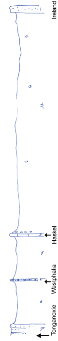
KGS Home

Geology Index Page

Wilson County

Sec. 24, T. 29 S., R. 13 E
Move to another county

Roadcuts and outlier of Ireland
Measured By Newell, 8/1938
Variation in Westphalia in 1/4 mile
Unit No. Description Thickness
1 Sandstone remnant, massive  
2 Shale, clayey, bluish gray, with limonite concretions, phosphatic nodules at base 107 ft.
3 Limestone, dense, blue blocky 1.5 ft.
4 Shale, gray, clayey, limey at top, with Myalina 18 - 24 ft.
5 Conglomerate of limestone pebbles in limestone matrix, some fossil shells, sandy, 0.3 ft up to 2 ft.
6 Shale, alvine clay shale, commonly absent, measures up to 25 ft.
7 Massive buff sandstone  

Original Document

The Archive file you download contains a TIFF image compressed into a ZIP archive. Your browser may be already set up to decompress these files. Commercial software to perform this is available from PKWARE, Inc., the company that invented the format. A web page from a group of people creating shareware or public domain software is available at Info-ZIP. The TIFFs are 150-dpi archival-quality color scans of the original forms and can be viewed by software like Corel PhotoPaint or Adobe PhotoShop.


Kansas Geological Survey
Comments to webadmin@kgs.ku.edu
URL=http://www.kgs.ku.edu/General/Geology/Measured/index.html
Programs Updated May 2003