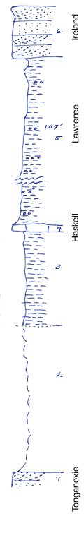
KGS Home

Geology Index Page

Wilson County

Sec. 19, T. 29 S., R. 14 E
Move to another county

Measured By Newell
Haskell well shown at cross section side of 24, 29-13
Unit No. Description Thickness
6 Brown massive, cross bedded sandstone 10 ft.
5 Gray clay shale with limonite concretions 107 ft.
4 Bluish-gray, dense limestone, filled with cryptozoans, crinoid stems, blocky 1.25 ft.
3 Greenish-gray clay shale with abundant Myalina and Chonetes at top 18 ft.
2 Shale (and limestone?) covered 27.5 ft.
1 Massive sandstone (Stranger)  

Original Document

The Archive file you download contains a TIFF image compressed into a ZIP archive. Your browser may be already set up to decompress these files. Commercial software to perform this is available from PKWARE, Inc., the company that invented the format. A web page from a group of people creating shareware or public domain software is available at Info-ZIP. The TIFFs are 150-dpi archival-quality color scans of the original forms and can be viewed by software like Corel PhotoPaint or Adobe PhotoShop.


Kansas Geological Survey
Comments to webadmin@kgs.ku.edu
URL=http://www.kgs.ku.edu/General/Geology/Measured/index.html
Programs Updated May 2003