|
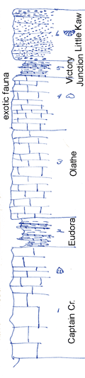
| Unit No. |
Description |
Thickness |
|
6
|
Buff and gray hard calcareous sandstone, varies to sandy and oolitic limestone; conglomeratic at base and top and granite pebble 2.5 in. across found at base; prolific fauna of strophomenoids, chiefly Derby spp and strepporhynchus offine (topotypes); also many other fossils including Syrungopora sp at top and Rhipidomella of carbonaria. The upper part of this is surely little Kaw and probably all of it is as determined by tracing of outcrops but it may be that the lower part is Victory Junction
|
10 ft.
|
|
5
|
Buff limy shale and gray, fine-grained limestone with calcite specks; shale contains spines and plates of large echinoid
|
2.4 ft.
|
|
4
|
Thin-bedded, drab to white, oolitic; very fossiliferous containing an exotic fauna in which Schixophoria cf texana is common; a careful search at all outcrops has failed to show this fauna outside of this place, probably because this is the only exposure including upper half of Stanton for scores of miles
|
10 ft.
|
|
3
|
Fine-grained gray, irregular limestone containing the normal fauna of Olathe limestone, Neospirifer, Squamalana, etc
|
14.5 ft.
|
|
2
|
Gray shale and shaly limestone, poorly shown
|
5.5 ft.
|
|
1
|
Very massive bluish gray limestone, brecciated appearing, with dense, blue lenses appearing in gray or brown matrix. Also some brown limestone lenses or irregular masses. Limestone flecked with clear specks of calcite; Enteletes pugnoides occurs below upper 4 ft., with E. plattsburgensis (rare) and Concrinella boonensis
|
20 ft.
|
|

