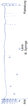
KGS Home

Geology Index Page

Wilson County

Sec. 1, T. 29 S., R. 15 E
Move to another county

Outlier of Plattsburg and creek exposures
Measured By Newell
Unit No. Description Thickness
1 Limestone, yellowish, poorly shown  
2 Shale, silty, buff, with limonite concretions in lower part, very silty in upper part 95 ft.
3 a)Limestone, oolitic, bluish, conglomeratic 0.3 ft.
  b)Shale, limy, gray 1.5 ft.
  c)Limestone, like (a) 0.3 ft.
  d)Shale, dark gray, limy 1 ft.
  e)Limestone, white, base not shown + 1 ft.

Original Document

The Archive file you download contains a TIFF image compressed into a ZIP archive. Your browser may be already set up to decompress these files. Commercial software to perform this is available from PKWARE, Inc., the company that invented the format. A web page from a group of people creating shareware or public domain software is available at Info-ZIP. The TIFFs are 150-dpi archival-quality color scans of the original forms and can be viewed by software like Corel PhotoPaint or Adobe PhotoShop.


Kansas Geological Survey
Comments to webadmin@kgs.ku.edu
URL=http://www.kgs.ku.edu/General/Geology/Measured/index.html
Programs Updated May 2003