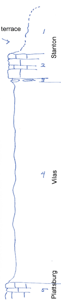
KGS Home

Geology Index Page

Wilson County

Sec. 12, T. 29 S., R. 15 E
Move to another county

Roadcuts
Measured By Newell, 8/1938
Unit No. Description Thickness
1 Limestone, white, massive, crinoidal, and shale, covered, makes terrace +/- 25 ft.
2 Limestone, white, cliff-forming, xln +/- 12 ft.
3 Limestone, dense, irregular, algal +/- 0.5 ft.
4 Shale, buff, silty, unfossiliferous +/- 100 ft.
5 Limestone, yellowish, irregular  

Original Document

The Archive file you download contains a TIFF image compressed into a ZIP archive. Your browser may be already set up to decompress these files. Commercial software to perform this is available from PKWARE, Inc., the company that invented the format. A web page from a group of people creating shareware or public domain software is available at Info-ZIP. The TIFFs are 150-dpi archival-quality color scans of the original forms and can be viewed by software like Corel PhotoPaint or Adobe PhotoShop.


Kansas Geological Survey
Comments to webadmin@kgs.ku.edu
URL=http://www.kgs.ku.edu/General/Geology/Measured/index.html
Programs Updated May 2003