|
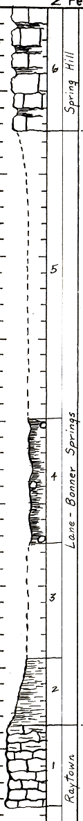
| Unit No. |
Description |
Thickness |
|
6
|
Limestone - dark yellowish orange (10yr6/6) to moderate yellowish brown (10YR5/4) weathered and olive gray (5Y4/1) to medium dark gray (N4) fresh, very fossiliferous with many Girtyocoelia and crinoid stems and local beds of brachiopods, shaly zones throughout. No evidence of lower bed (Merriam) but base is not well shown. No oolitic facies apparent.
|
15 ft.
|
|
5
|
Covered interval
|
35 ft.
|
|
4
|
Claystone - yellowish gray (5Y7/2), unfossiliferous, in part shaly, breaks into angular fragments, contains a very few ironstone concretions
|
15 ft.
|
|
3
|
Covered interval
|
14 ft.
|
|
2
|
Shale - non-silty to very slightly silty, medium light gray (N6), weathers light olive gray (5Y6/1), unfossiliferous, exposed for 8 ft. in the river bank
|
8 ft.
|
|
1
|
Limestone - base not exposed; bedding well developed locally and shows rather irregular large folds; light gray (N7) to very light brownish gray (5YR7/1); contains many interlaminated clay partings, irregularly distributed; fossil content abundant throughout and fine specimens can be obtained from weathered clay partings. Fossils: very abundant crinoid columnals throughout and locally abundant and well preserved productids, fenestellate bryozoans, oysters(?), and small pelecypods(?). This limestone has a very dirty appearance, weathers to a most irregular angular surface and locally has pale reddish brown (10R5/4) blotchy areas about 3 ft. from the top. A 5 inch bed of dark gray (N3) very fine grained hard limestone occurs locally at the top but grades laterally into 6 inches to 17 inches of very fine grained hard, mottled dark gray (N3) and medium light gray (N6) limestone; this unit is less fossiliferous and much harder than most of this bed. The very irregular nature of this bed and its variable fossil content and lithology suggest biostromic accumulation to me. It is locally cross-bedded. Shale beds become increasingly thick but very lenticular in the upper 3 ft. and in general the upper 2 ft. is dark gray (N3) very calcareous shale which is very fossiliferous with irregular lenticular masses of limestone throughout. This shale weathers back to leave a sharp capping rock which is 3-5 inches resistant limestone, clayey and very fossiliferous. A small fault (1 ft. displayed) breaks this limestone and drops the west side down; later calcite has cemented the break N5R, 80W dip
|
10 ft.
|
|

