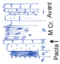
KGS Home

Geology Index Page

Wilson County

Sec. 16, T. 29 S., R. 17 E
Move to another county

Roadcut
Measured By Newell, 8/1938
Bed #4 unusually thin here
Unit No. Description Thickness
1 Limestone, yellowish, sandy, nearly complete +/- 4 ft.
2 Shale, upper 1.8 gray, lower part black, fissile, with phosphatic concretions 4.3 ft.
3 Limestone, light gray, dense 0.3 ft.
4 Sandstone, calcareous, brown 1.5 ft.
5 Coal + 1 ft.
6 Underclay  

Original Document

The Archive file you download contains a TIFF image compressed into a ZIP archive. Your browser may be already set up to decompress these files. Commercial software to perform this is available from PKWARE, Inc., the company that invented the format. A web page from a group of people creating shareware or public domain software is available at Info-ZIP. The TIFFs are 150-dpi archival-quality color scans of the original forms and can be viewed by software like Corel PhotoPaint or Adobe PhotoShop.


Kansas Geological Survey
Comments to webadmin@kgs.ku.edu
URL=http://www.kgs.ku.edu/General/Geology/Measured/index.html
Programs Updated May 2003