|
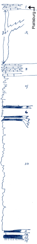
| Unit No. |
Description |
Thickness |
|
1
|
Limestone, yellowish, erosion remnant
|
|
|
2
|
Shale, gray, silty, unfossiliferous
|
80 ft.
|
|
3
|
Limestone, poorly exposed, about
|
+/- 4 ft.
|
|
4
|
Sandstone, thin-bedded, wave-riffled
|
12 ft.
|
|
5
|
Coal with silicified log; the occurrence of silic. wood 8 - 12 ft. below the Iola in a coal bed may be important in correlating these coals in eastern Wilson county; I am not so sure as formerly that the coal at the base of the sandstone section is the same from place to place
|
0.3 ft.
|
|
6
|
Sandstone, thin-bedded, buff, fine
|
3 ft.
|
|
7
|
Coal
|
0.02 ft.
|
|
8
|
Shale, silty, gray, with fern leaves
|
0.2 ft.
|
|
9
|
Coal
|
0.2 ft.
|
|
10
|
Sandstone, blocky, buff, wave-rippled. Lower 14 ft. shaley
|
40 ft.
|
|
11
|
Coal
|
0.5 ft.
|
|
12
|
Shale, gray
|
0.5 ft.
|
|
13
|
Coal
|
+/- 1 ft.
|
|
14
|
Underclay
|
|
|

